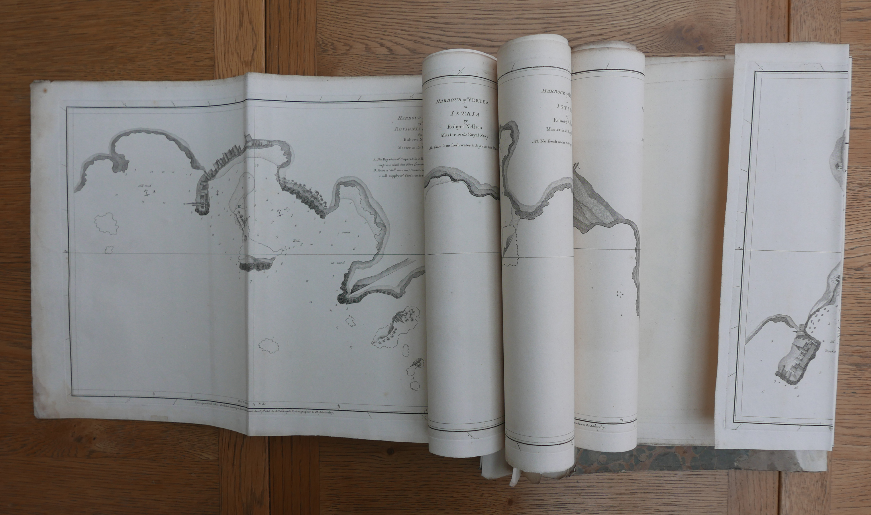
THE ADRIATIC CHARTS by Robert Nellson, and other Dalrymple' charts + two being manuscript. Together THIRTEEN CHARTS. Complete Small folio and then folding on thick uncut paper within the contemporary marbled limp [worn] covers. LIST OF CHARTS : 1) Harbour and Bays of Rovignia in Istria. 2) Harbour of Orsera in Istria. 3) Parenzo in Istria. 4) Bay of Citta Nova of Porto Quieto in Iatria. 5) Paran Bay on the Coast of Istria. 6) Harbour of Polo and Road of Fasano in Istria. 7) Harbour of Liesina on the Island Liesina in the Adriatic. 8) Oristana Bay in the Island Sardinia surveyed by Robert Davison, Master in the HM Ship Kent November 1802. 9) Plan of Part of the E. Coast of the Island of Sardinia 1789. 10) Plan of Ogliaster Bay on the Island of Sardinia from the English MS. in the Hydrographical Office. 11) Plan of Tunis Bayfrom an English MS in HM Ship Pearl supposed by Hon. Capt: Seymour Finch. 12) Appearance of the land from Point Telamon to Mount Agrentat, from the Cameleons anchorage in Telamon Bay (manuscript). 13) Chart of the Harbour of Syracuse. (manuscript). [ ' early Admiralty charts of harbours and anchorages in the north-eastern part of the Adriatic. They were surveyed by Robert Nellson, a Master in the Royal Navy, but not the Nelson we all know! They were published by Alexander Dalrymple between 8th March and 20th May 1803. charts are of anchorages and harbours in Istria, the peninsula at the head of the Adriatic, and a chart, 'Harbour of Liesina on the Island of Liesina' is on the island of Hvar, about 150 miles farther southeast off the coast of Dalmatia. None of these charts are graduated, either for latitude or longitude. On six of them north is to the left, on one of them it is to the top and on the other to the bottom. All the charts were withdrawn by the Admiralty prior to 1822 and perhaps even earlier and, in consequence, very few others have survived. They could best be described as plans as the largest measures 285 x 410 mm and 286 x 210 mm. Published by Dalrymple, who was appointed Director of the Hydrographical Office in 1795, to support naval operations in the Mediterranean during the Napoleonic War, and were presumably withdrawn at the end of hostilities when they were of no further use to the Royal Navy'].' Nellson's subsequent career can be told briefly from his service record. After leaving El Corso on 26th July 1802, Nellson joined the Pique on the West Indies Station, serving in her between May 1803 and March 1804. He was then appointed to the 74-gun Duquesne, but shortly after he joined her she ran aground on Morant Cays, south-east of Jamaica. At the subsequent court martial on 2nd April 1804, Nellson was ordered to be dismissed from his ship and placed at the bottom of the list of Masters and 'to serve on board any of His Majesty's Ships that the Commander-in-Chief shall think proper to direct'. In spite of this apparent setback to his career he was immediately appointed to the fifth rate Clorinde, followed by the Proselyte, and then the Malabar and Racehorse on the Cape Station, in which he served until 30th June 1810, which is when his service record ends'.] Rare & Excellent.